Setturu Bharath – Spatial Informatics
Setturu Bharath received his doctorate in Spatial Informatics. His research work was supervised by Prof. K S Rajan. Here’s a summary of Bharath’s thesis, Modeling landscape dynamics with biodiversity, ecology and social aspects as explained by him:
I carried out my doctoral work under the guidance of Prof. K S Rajan and Prof. T V Ramachandra (CES, IISc, Bengaluru) from Lab of Spatial Informatics (LSI). I have worked on “Modeling Landscape Dynamics with Biodiversity, Ecology and Social Aspects”, during the course of Ph.D. I tried to understand the linkages between landscape, ecology and social responses. Landscape is a mosaic of forested, non-forested fragments of land that differ from area to area depending on climate, land uses, and history. There is an intrinsic relationship between anthropogenic pressure and landscape health. There has been increasing apprehensions about environmental degradation, depletion of natural resources due to uncontrolled anthropogenic activities, and its consequences on long-term sustainability of socio-economic systems around the world. This necessitates an understanding of landscape dynamics and the visualization of likely changes for evolving appropriate strategies for prudent management of natural resources. Modeling of forest cover changes offers to incorporate human decision making on land use in a systematic and spatially explicit way through an accumulation of land use choices, social interaction, and adaptation at various levels. Several models developed by the research community so far has largely been utilized to evaluate the empirical studies, explore theoretical aspects of particular systems rather than forecasting their effectiveness across the various landscapes representing bio-physical dissimilarities. Hence, there is a need to demonstrate an appropriate modeling technique, that captures the current degradation in an effective way as compared with the traditional agent-based or non-agent based land use change modeling techniques.
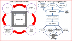
Figure1. Landscape interactions and landscape degradation
In this regard, the objectives of current research are to understand and proposed a new hybrid model to capture the spatiotemporal patterns of landscape dynamics in the Uttara Kannada district of the Central Western Ghats and evaluating the environmental conditions in response to scenarios of drivers of change like developmental policies as well as their potential impacts.
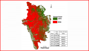
Forest cover loss from 1974 to 2016
Research Highlights:
- Landscape dynamics are assessed through land use analysis using temporal remote sensing data through a supervised classifier based on the Gaussian Maximum Likelihood algorithm for the period 1973 to 2016.
- Land use analyses reveal the trend of deforestation, evident from the reduction of evergreen semi-evergreen forest cover from 67.73% (1973) to 29.5% (2016).
- Loss of forest cover of 3329 sq.km over four decades in the study region is due to the implementation of developmental projects such as the construction of a series of dams, etc.
- Proposed Hybrid Fuzzy-AHP-MCCA model for the forest landscape with a systemic multi-criteria decision evaluation.
- Drivers of change were accounted for simulation to predict land uses of 2022 under two different scenarios such as reserve forest protection (P*) and absence of protection (P_WRF) using MCE.
- Hybrid modeling with a managed growth rate scenario approach has provided an efficient model of forest transitions as compared to other models. The model reveals that forest land cover would decrease by close to 10% from 54.17 to 45 % by 2022 in the absence of reserve forest protection with escalating population density.
- ESR scenario provided policy insights for conservation of the ecologically sensitive regions through likely protection of forest cover of 4990 km2 with the constrained ESR-1 scenario leading towards the sustainable development of the region.
Field observations: