
Salghuna received her doctorate in Spatial Informatics. Her research work was supervised by Dr. Ramachandra Prasad Pillutla.
Here’s a summary of Salghuna’s thesis, Approaches for Spectral Characterization of Tree Species of Araku Forest, Eastern Ghats Using Chris-Proba Imagery and Canopy Upscaling Models by Assimilating Leaf Biophysical- Chemical Parameters as explained by her:
The advancements in hyperspectral remote sensing escalated the research in forestry-related to species identification, discrimination, and health assessment. The technology aided in the development of a spectral library of various species that enable researchers to map species without the need for an expensive field inventory. The research focus of this thesis is to generate a temporal spectral database for ten selected species of Araku forest, the Eastern Ghats using field inventories (multiple seasons), hyperspectral satellite data, and canopy upscaling models.
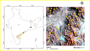
Figure 1: Study Area
The properties of leaf/bunch of leaves sampled from the bottom of trees may vary, and a direct analogy with canopy properties will lead to substantial overestimation/underestimation of the spectral reflectance of the tree.Hitherto researchers applied upscaling techniques with well-known PROSPECT, SAIL, FLIGHT models, but so far, no model (in forestry) developed for leaf upscaling, within the country using field-collected leaf reflectance spectra and their biochemical parameters. Towards this objective, the current study proposes an upscaling model “SEMULS” (Semi-Empirical Model for Upscaling Leaf Spectra), a unique and first of its kind of model to upscale leaf spectra to canopy.
The spectra extracted for the selected species from satellite data are correlated with canopy spectra derived from leaf reflectance spectra obtained from the field using SEMULS.
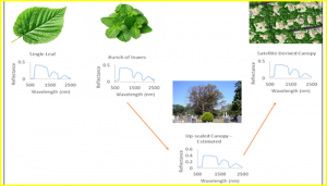
Figure 2: Upscaling concept
The outputs of the model are validated for its applicability by comparing with upscaled spectra derived from popular PROSPECT and DART 3D models. The SEMULS model is unique in retaining the minute dips and peaks of the spectra, which are important in discriminating (80% matching at 5deg or less threshold) species, unlike other models that smoothen spectra using different filters. The upscaled canopy spectra (SEMULS) is further used to classify selected species in the study area from CHRIS-PROBA satellite data, using the SAM method and validated based on GPS locations observed from the field. The study also proposed few experiments such as upscaling spectra for chlorophyll region without field inventory or upscaling model, mapping species – from the spectra extracted from literature and use of spectra of one location to map same species in other regions, discriminating species using DART model and an algorithm to decompose Sentinel data to hyperspectral data.
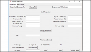
Figure 3: Interface of SEMULS model
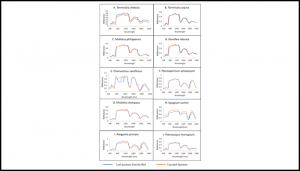
Figure 4: Comparison with leaf and upscale results
The developed database enhances the reliability and comparability of the datasets allowing multi-temporal and multi-scale studies. The database is uploaded in the NISA portal (spectral library) which will serve present and future researchers, in identifying the species without field inventory,and/or for any spectra related research.