
In India, at least 10,000 people have died in the last 2 decades due to landslides alone. 110 districts spread across 16 states are prone to landslides every monsoon. Today, our country has enough technologies available to involve every citizen in disaster prediction and management. The government already provides these tools to officials. The time is ripe to open it up and involve entire citizenry. “Public Policy” needs to be Public owned, in spirit and letter, in our geographically diverse nation. When private mapping firms can successfully tap crowd sourcing solely for profits, the Government of India too can certainly emulate the model for better disaster preparedness.
The Kerala State Disaster Management Authority has been doing exactly this by meticulously creating awareness Talks on disasters to providing Landslide Susceptibility Maps on their website for researchers and the public to access. However, as the Wayanad catastrophe demonstrates, much more can be done.
Year after year, especially from 2018, Kerala is bearing the brunt of relentless floods and massive landslides. The excessive loss of life and property highlighted the need for an integrated approach for disaster management. In 2022-23, the state government received a request for approval of a new pilot project – to develop a Landslide Early Warning System (LEWS) in Pullurampara, Kozhikode District. However, the development of a LEWS is easier said than done, even, internationally, as it is a matter of research and development.
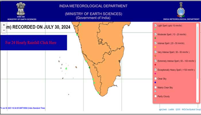
The said project proposed a new approach of Global Navigation Satellite System (GNSS)-based Tomography technology for hyper-local weather forecasting. The dynamic part involved in such forecasting is the information pertaining to real time precipitation quantum. Indian Meteorological Department (IMD) today provides 3-hourly and 24-hourly rainfall maps measured using automatic weather stations/gauges at select locations in India. Unfortunately, there are hardly a handful, maintained by IMD at Wayanad at the landslide susceptible regions. A wildlife research group at Wayanad – Hume Centre for Ecology and Wildlife Biology – does maintain about 200 rainfall sensors and disseminates relevant information to vital stakeholders.
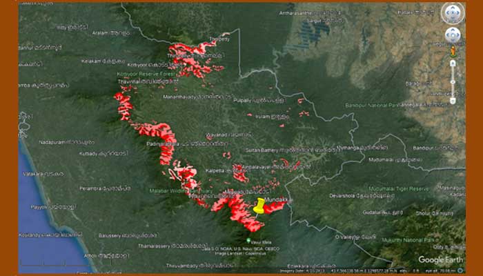
To put things in perspective, location of Mundakkai, where the first landslide took place, is marked on KSDMA’s map (yellow). The entire district, especially at its border with Malappuram falls in the High/Medium Landslide Susceptibility Zones.

Whither Alerts?
As of today, there are no online government platforms for the common public where real time rain information is overlaid with landslide susceptibility maps. Such data is crucial to give a heads up about a potentially incoming disaster. There are a few private apps such as Kerala Rain for Android mobile phones providing rain alerts but their operations are intermittent.
IMD Maps: More Details Required
IMD has a dedicated website for rains (mausam.imd.gov.in) wherein, district-wise rainfall-alert maps are provided regularly. But these maps are not overlaid on Bhoonidhi or Open Street Maps for easy identification of vulnerable areas. With climate change causing inconsistent, extreme weather events, it is not enough anymore, that only District Collectors are privy to the details to issue evacuation orders towards relief shelters.
The rainfall details need to be transparently shared in real time (even if fraught with marginal errors) with the public in local languages and in English for international tourists. The information dissemination is more of a mandatory requirement for districts with hills, rivulets and forests since rivers can even suddenly change their due to cloudbursts. Additionally, heavy rainfall tends to begin post-6 PM, due to diurnal temperature variations and peaks in intensity post-midnight when the populace is in deep sleep.
Manual methods (like loudspeaker-based announcements) to caution people dwelling beside riverbanks about potential breaches are inadequate because landslides strike at a totally different pace. People need upwards of ten minutes to even start running down the hills to safer zones. The physically and mentally challenged, sick and infirm, domestic as well as stray animals have no chance to act fast even if sirens are issued 10 to 20 minutes ahead of an occurrence.
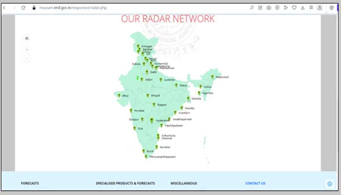
Although IMD also has a great pan-India, Doppler Weather Radar (DWR) network, there are only 2 DWRs operating in Kerala. Heavy rainfall occurs mostly in the hilly regions of Western Ghats where districts of Pathanamthitta, Idukki, Wayanad lie and this zone has no DWR.
While RADAR map interpretation knowledge requirement is certainly technical, there are a few issues with the format in which this information is disseminated via Mausam website.
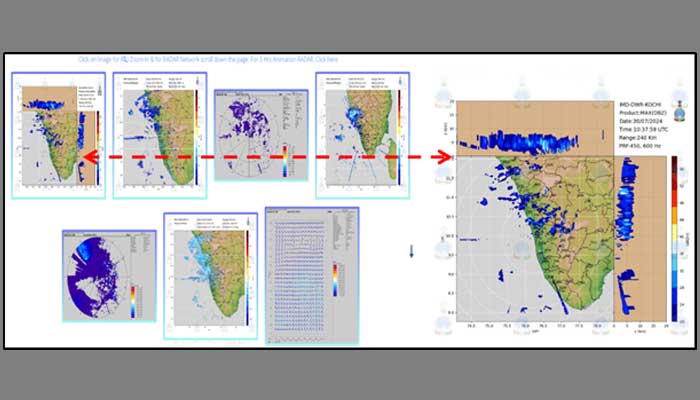
The spatial distribution of maximum reflectivity (DBZ) is provided in decibels to denote rain (or other precipitation) intensity measured by a radar signal after hitting a rain drop. The intensity of rain is shown in legend using colours (blue to red marks heavy spell). Thus, even literates can quickly get an idea of the severity even though Radar maps are not 100% complete or correct in any country. But this need not be a deterrent for withholding the information in an easy-to-consume format.
On the Mausam website, RADAR maps are available only in GIF file format and not in kml/kmz formats. Even in the Mausam Android map, these RADAR images are provided as screenshots instead of overlaying them on Google Maps that comes freely bundled with all Android phones today. The Rain Alert feature in the app provides information for a radius of up to only a few kilometres based on the current location of the user. But most of the landslide triggers happen several kilometres away in the higher hilly regions. At the time of writing this article, even this feature was unavailable for the current location and the map did not load despite good mobile network connectivity.
Open-Source Radar Images
Given these numerous challenges even for the district administration, IMD can open up its RADAR images on top priority to public so that both commercial and non-commercial apps flood the market in a healthy competition to precisely track the path of clouds, quantum of rains possible at hyper local levels. This will also motivate crowd sourcing of hyperlocal weather data which will provide feedback to IMD servers and directly aid in improving the accuracy of IMD’s disaster predictions, utilising their superior computational facilities.
In summary, until a sophisticated real time Landslide Prediction and Warning System is rolled out across Kerala, the state deserves the installation of additional Doppler Weather Radar for the ghats region. And more importantly, with this, the monsoon still very active, all the historical and live radar images, when opened up to public immediately, can start saving lives across our country.

Malini Krishnan is a researcher at IIITH’s Lab for Spatial Informatics (LSI) under the guidance of Prof K S Rajan. Her interests lie in the prediction of natural disasters. Her master’s research involved arriving at a methodology to understand the volcanic eruption impacts on airspace safety by improving Numerical Weather Prediction model estimates.
Next post