M Vani received her doctorate in Civil Engineering. Her research work was supervised by Prof. P Rama Chandra Prasad and thesis reviewed by Prof. Pradeep Ramancharla, IIIT Hyderabad, Dr. Arindam Biswas, IIT Roorkee and Dr. Reet Kamal Tiwari, IIT Ropar.
Here’s a summary of Vani’s thesis, Modeling land use-land cover transition induced microclimate changes: A case study of Vijayawada city, Andhra Pradesh, India as explained by her:
Urbanization is a rapid and inevitable trend around the world with seemingly no sign of abating. The way in which urban sprawls are sustainably managed can be a major force for global adverse climate change mitigation and adaptation strategies; that entails better mass transit, more efficient lighting and heating systems for buildings, improved waste management and cleaner sources of energy production. All can ultimately have large positive effects for reducing climate change but are rooted in locally oriented strategies. The thesis thus aims to analyze the relationship between urban expansion and microclimate temperature fluctuations and develop an algorithm to forecast the land surface temperature (LST) based on the predicted land use-cover changes (LUCC). The defined objectives were achieved by: (1) Quantifying the decadal land use-land cover (LULC) variations of the study area from 1990 – 2018; (2) Identification of the LUCC pattern; (3) Identification of the drivers of change for the city; (4) Predicting the expansion of the city and the pattern shift if any; (5) Quantification of the temporal variations of LST during summer and winter; (6) Establishing a relationship between the different LULC classes and their impact on the LST; (7) Forecasting the LST associated with the predicted city changes; (8) Develop and test soft measures to combat the intensifying LST.
Future increase in the size of the world’s urban population is expected to be highly concentrated in developing countries that include India as well. The total number of towns and urban agglomerations were reported as 393 and 465 as per the 2001 and 2011 India census. In this regard, the thesis examines the urban agglomeration of Vijayawada city, Andhra Pradesh, India as the case study to validate the developed algorithm. The city expansion and the associated temperature fluctuations were studied with the aid of remote sensing technology. Results showed a steady increasing trend in the urban density and LST with the distinct formation of a heat island over the city especially during winters throughout the study period. The built-up area has increased from 28.20 km2 in 1990 to 138.01 km2 in 2018. With a precise analysis of the past trend of city growth, a cellular automata (CA) based hybrid algorithm in combination with genetic algorithm (GA) was developed to model the future scenario of the city in 2020 and 2030. The developed model was further compared with an established urban growth model (UGM), SLEUTH (Slope, Land use, Exclusion, Urban extent, Transportation, Hill shade). On an extended note, the research also developed a graphical user interface (GUI) for the SLEUTH-UGM; that otherwise had bugs and complexities in implementation. The developed scenarios of the city showed maximum growth of the city towards the east direction covering Gunadala. Vijayawada records an increase in the mean minimum temperature over time during winters around 21 ⁰C in 1990 – around 30 ⁰C in 2018. This accounts to an average increase of about 7 ⁰C – 10 ⁰C in the minimum temperature observed during winters especially around the built-up areas in Vijayawada. This significant increase in temperature may also be attributed to the conversion of water bodies to built-up (in Kummaripalem, Film colony, Santhinagar) and reduction in the size or desiccation of water bodies (around Vijayawada new west cabin) over time in and around the study area.With the knowledge of the temperature fluctuations observed during summer and winter seasons over the study area for the past 28 years and based on the projected scenario of LUCC for 2020 and 2030, a novel algorithm was developed to predict the LST over the study area. The algorithm based on Kernel Ridge Regression (KRR) serves as a bridge to fill the existing gap between the spatial variable (LULC) and the climatic variable (LST); thereby adding to the existing knowledge on microclimate change related studies. Different test cases to validate the stability of the algorithm for varying image resolutions and the computational efficiency has also been logged successfully. With the projected scenarios of the city for 2020 and 2030, the algorithm predicted an average increase in the temperature of about 2 ⁰C – 3 ⁰C for all the LULC classes during both the seasons with a significant reduction in the temperature gap within individual classes.
Many studies have been performed to analyse the LUCC of a location over time using Remote Sensing technology. Modeling the future scenario of a region has also been done quite broadly using readily available software in recent years. However, the studies often restrict themselves within analysing the changes and modeling the future scenarios. Though climate change has been a debatable topic over the past decade, seldom studies relate the actual geographical changes and the associated microclimate fluctuations. This thesis thus stands out by bridging the gap between them by developing an algorithm that relates the spatial variable (LULC features) and the climatic variable (LST). This further adds to the existing knowledge on microclimate change related studies. Further the thesis also extends to recommend practical solution for the increasing temperatures observed in the chosen city scale congested street canyon. On an extended note, the thesis also covers the development of a GUI for an established UGM; which otherwise has bugging issues and complexities in implementation. This contributes towards the development of an existing system thereby improving the efficiency of the model available.
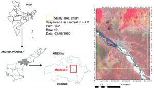
Geographical location of the study area
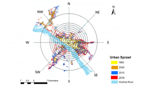
Spatio-temporal growth of the city
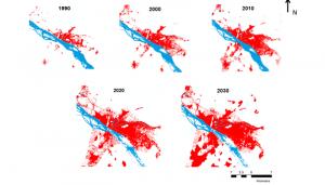
Built-up expansion of Vijayawada modeled by the SLEUTH-UGM
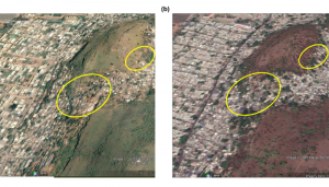
Built-up expansion along the hill slopes witnessed through Google Earth in (a) 2001 and (b) 2019 (Courtesy: Google Earth)
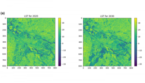

LST predicted for (a) summer (b) winter
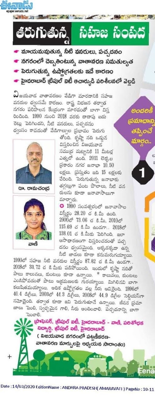
The thesis work was also featured in the Eenadu Amaravati, AP dated 14/03/2020